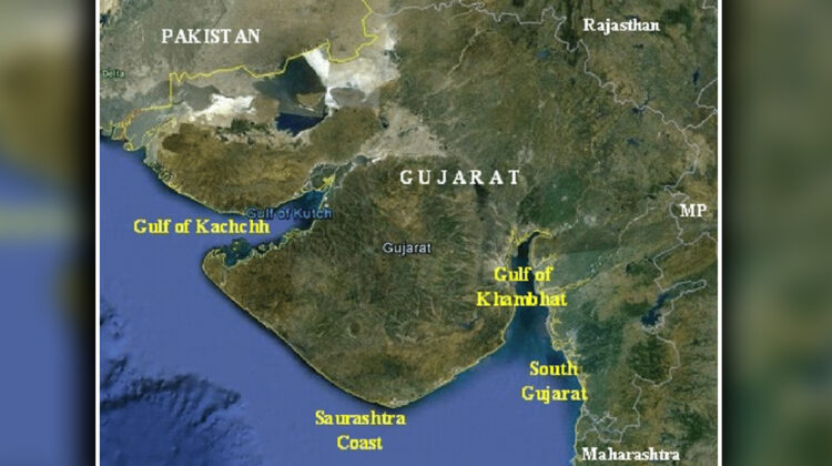
Gujarat’s coastline is no more 1,600 km; it’s revised to 2,340.62 km now
GANDHINAGAR : In a significant development, India’s coastline has officially been revised to 11,098.81 km, marking an increase of 3,537.21 km, or nearly 50%, from the previous measurement of 7,561.60 km. With this revision, the coastline of Gujarat, which is the longest in the nation, is no longer 1,600 km; it is now over 2,300 km.
The revised calculation follows a new methodology, as announced by the Transport Research Wing of the Ministry of Ports, Shipping, and Waterways in a circular dated April 29.
As per an official circular – for decades, the Ministry of Home Affairs reported the coastline length at 7,561 km, a figure that had been used since the 1970s. However, discrepancies existed as different government departments had used varying figures. A review of the issue, initiated in 2019, revealed that the Coastal Protection and Development Advisory Committee (CPDAC) had been deliberating on the subject since 2010.
Later, in a meeting in August 2019, CPDAC accepted the new length of India’s coastline, computed by the National Hydrographic Organisation (NHO), Dehradun, as 11,084.50 km, along with the methodology for its computation.
As a result, Gujarat’s coastline, initially estimated at 1,600 km, has now been officially revised to 2,340.62 km, making it the longest coastline in India.
The state-wise/UT-wise ‘Length of Coastline of India’ is as follows:
SI No. State/Union Territory Coastline length (in km)
1 Gujarat – 2,340.62
2 Maharashtra – 877.97
3 Goa – 193.95
4 Karnataka – 343.30
5 Kerala – 600.15
6 Tamil Nadu – 1,068.69
7 Andhra Pradesh – 1,053.07
8 Odisha – 574.71
9 West Bengal – 721.02
10 Daman & Diu – 54.38
11 Pondicherry – 42.65
12 Lakshadweep Islands – 144.80
13 Andaman & Nicobar Islands – 3,083.50
Total Length of Coastline of Indiav-11,098.81
The revision of the coastline length is primarily attributed to differences in the scale and calculation methods. The earlier figure, calculated in the 1970s, was based on records at a scale of 1:4,500,000, whereas the newly verified data was calculated at a much finer scale of 1:250,000. The change in scale has led to the increased coastline measurement, as the circular clarified that variations can occur when measured from maps of different scales.
A note by Ministry of Ports, Shipping and Waterways Transport Research Wing stated – ‘The main reason for the deviation in the existing coastline length of 7516.6 kms as per MHA records and the re-verified coastline length of 11098.81 kms is due to theprobable variation in scale and calculation methods. The length of coastline calculated in 1970s might have been computed from the then available records at the scale of 1:4,500,000 or smaller whereas the re-verified data has been computed at the scale of 1:250,000. It is understood that the length of coastline is liable to vary when it is measured from maps of different scales. The larger the scale of map greater may be the outcome of the length. This is because larger scale data capture more intricate details like bays, inlets, and minor irregularities that are smoothed out at smaller scale data. Further, conventional/ manual methods might have been used for the computation of the 1970 data whereas modern GIS software have been used for the computation of the re-verified data. The no. of offshore islands/islets of India are finalised as 1298 Offshore islands/islets (1059 islands and 239 islets) in the reconciliation exercise of the offshore islands of India. Secondly,the length of offshore islands has been added in the total length of there-verified coastline which might have been left out in the 1970s coastline length due to scale constraint and conventional/ manual measuring methods. Further, peripheral coastline(High-Water Line) of individual offshore islands has been used for the calculation of coastline length.’
Salient Terms of Reference (ToR) for measuring Re-verified Length of Coastline of India (11,098.81 kms) are as mentioned below:
a. The length of coastline has been measured at the High-Water Line with base data of 2011 on Electronic Navigation Charts (ENCs) prepared by the National Hydrographic Office (NHO).
b. The datum and projection for the coastline length is WGS-84 and respective UTM Zones.
c. The scale has been generalised to 1:250,000 or lesser using ENCs of NHO
d. Mouth of the rivers, creeks, estuaries, backwaters, etc. have been closed at suitable places by NHO and only segment of length closing of river mouth has been considered.
e. The length of coastline of islands which get connected to mainland during low tide conditions has also been added in the length of coastline.
f. The ‘Length of Coastline of India’ will be reviewed in a cycle of 10 years with newer data sets.
Source : DeshGujarat